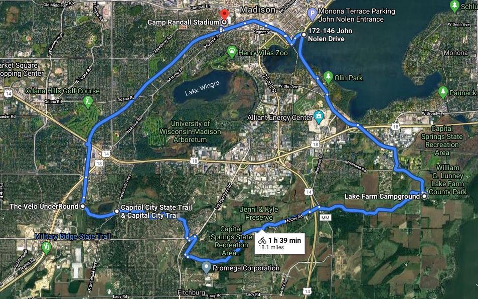
The route (19.1 miles) outlined below is almost entirely on dedicated bicycle paths. It takes about two hours for the average cyclist. The route below incorporates the detour that will last until the summer, 2027.
_________________________________________________________________________
Camp Randall to Velo UnderRound - 4.5 miles
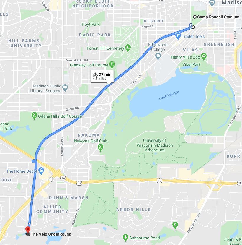
The ride starts across from Camp Randall Stadium at the intersection of Regent, Monroe and Breese streets. There is a BCycle station, 92 S. Breese Terrace, where you can rent an electric bike. You will begin traveling west on the Southwest Commuter Path, a paved path that follows the route of the Illinois Central Railroad branch built in 1887 between Freeport, Illinois, and Madison. For the first three miles there is a slight incline until you reach the bicycle/pedestrian overpass at the beltline. Continue until you reach the Velo UnderRound.
The Velo UnderRound marks the junction of five trails: the Capital City State Trail, the Southwest Commuter Path, the Military Ridge State Trail, the Badger State Trail, and the Cannonball Path. There is also access to the Seminole Mountain Bike Trails.
_________________________________________________________________________
Velo UnderRound to Lake Farm Campground - 7.8 miles

To continue on the Capital City State Trail, you will need a State Trail Pass.
Continuing on the Capital City State Trail, just before reaching Seminole Highway, you will see the Dawley Bike Hub on your right. It has a bike repair station, parking, restrooms, and water (might be closed during the Covid-19 pandemic). After crossing Seminole Highway the trail is uphill for a short distance. On the portion of the trail between Seminole Highway and Fish Hatchery Road, you will see Ashbourne Pond where there is a spur to the Cannonball Trail.
At Fish Hatchery Road there is a bicycle/pedestrian overpass. After the overpass you will turn right on Glacier Valley Road for a mile (the only portion of the loop that is not on a bicycle path). At the junction of Glacier Valley Road/Gunflint Trail, turn left to continue on the Capital City Trail.
This portion of the trail parallels the Capital Springs State Recreation Area for nine miles. Points of interest along the Capital Springs State Recreation Area include: Lake Farm County Park and Campground, Lussier Family Heritage Center, Lewis Nine Springs E-Way, Capital Springs Disc Golf & Dog Park, Jenni and Kyle Preserve, Nevin Springs Fish & Wildlife Area, Monona Wetland Conservancy, Upper Mud Lake, Madison Metropolitan Sewerage District Wildlife Observation Unit, Capital Springs Centennial State Park, and the Gilman Native American Mounds.
______________________________________________________________________
Lake Farm Campground to Waunona Way - 2 miles

At Lake Farm Campground there is a kiosk marking the junction of the Capital City Trail and the Lower Yahara River Trail. At this intersection you can also see the Lussier Family Heritage Center which connects the community to natural resources through education, recreation, and experiences.
Turn left at the junction to continue on the Capital City State Trail. On the right is a boardwalk providing access to the Nine Springs E-way Observation Deck. Further on you will be biking by the Madison Metropolitan Area Sewerage District wildlife observation area with good birding opportunities. Madison's sewer plant will be on your left. Where the trail meets Waunona Way, if you turn right you will be doing the Lake Monona Loop with the Detour. However turn left on the Capital City Trail.
_
_________________________________________________________________________
Waunona Way to Southwest Commuter Path/North Shore Drive - 3.4 miles

Turn left on the Capital City Trail until you reach the Wingra Creek Bike Path where you will turn left. A short distance further you will see a junction where left goes to Quann Park and right goes to Van Deusen street. Turn right and continue on Van Deusen street until Rowell street. Turn right for three blocks on Rowell street where you will turn left on the Lakeside street off-street bike path for one block. A good stopping off point here is the Lakeside Street Coffee House at 402 W. Lakeside street. Turn right on Gilson street for one block where you will reach South Shore Drive. Shore South Drive runs into West Shore Drive which runs into the Brittingham Park Bike Path which you will take until you run into the junction of North Shore Drive and the Southwest Commuter Path.
________________________________________________________________________
Southwest Commuter Path/North Shore Drive to Camp Randall - 1.4 miles

Turn left on the Southwest Path/Greenbush Link which will take you back to your starting point, Camp Randall.
_________________________________________________________________________
BCycle Stations along the Route
Madison BCycle has a number of stations along the route where you can rent an electric bicycle. The following map lists some stations within a block of the route.

_________________________________________________________________________
Other Resources
Dane County Bicycle Map
Madison BCycle
Madison Bikes Community (Facebook)
Madison Bikes
Bicycle Benefits
Top 10 Trails to Try in Madison
Biking in Fitchburg
The Ultimate Guide to Biking in Madison Wisconsin
Your Guide to the Lake Monona Bike Loop
_______________________________________________________________________
Compiled by Bob Shaw - robert.e.shaw@gmail.com
July 2020; updated July 2026