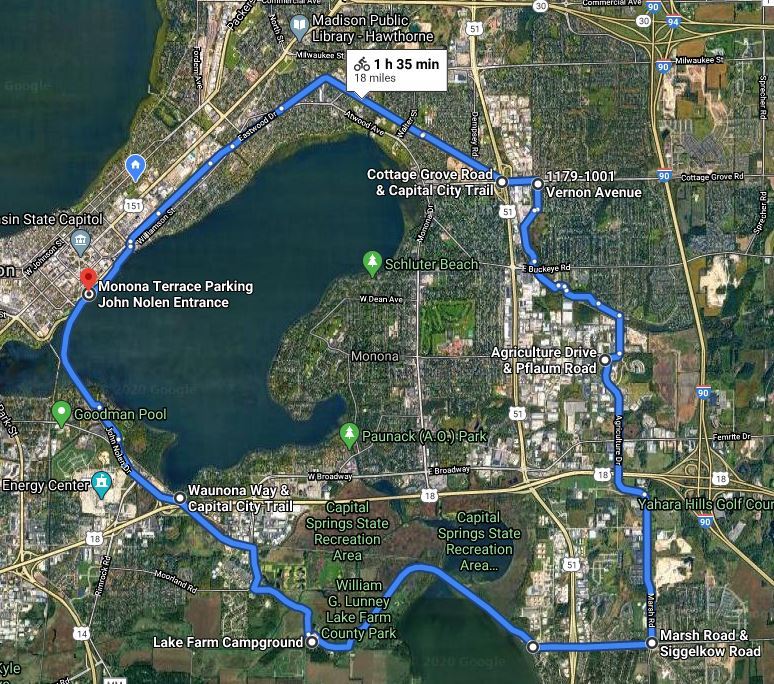

The route (19.5 miles) outlined below traverses a mixture of bicycle paths and city streets with bike lanes. It takes about two hours for the average cyclist.
Because of construction on John Nolen drive, there is a detour around Monona Bay that has added 1 1/2 miles to the usual route. The detour will last until the summer of 2027.
_________________________________________________________________________
Monona Terrace to Waunona Way - 3.9 miles

Shortly after leaving Monona Terrace cross John Nolen drive at Broom street. Turn left on Broom street and follow the paved off-street bike path that parallels John Nolen Drive for a few blocks until you reach Bedford street. If you want to reach the Southwest Commuter Path continue straight for one block where it intersects with North Shore Drive. However if you want to do the Lake Monona loop, cross North Shore Drive at Bedford and turn right on the Brittingham Park Bike Path. The route now follows Monona Bay on the Brittingham Bike Path, West Shore Drive, and South Shore Drive. When you reach Gilson street turn right for one block until you reach Lakeside street. Turn left on the off-street bike path on Lakeside street for one block until you reach Rowell street.
A good stopping off point here is the Lakeside Street Coffee House at 402 W. Lakeside street. Turn right on Rowell street for three blocks until Van Deusen street where you turn left. Follow Van Deusen street to the end where you will see a sign for the Wingra Creek Bike Path. On the Wingra Creek Bike Path turn left to get to Olin Park and the Capital City Trail where you turn right. Just before Waunona Way and the railroad tracks, there is a junction where you turn right on the Capital City Trail.
_________________________________________________________________________
Waunona Way to Lake Farm Campground - 2 miles
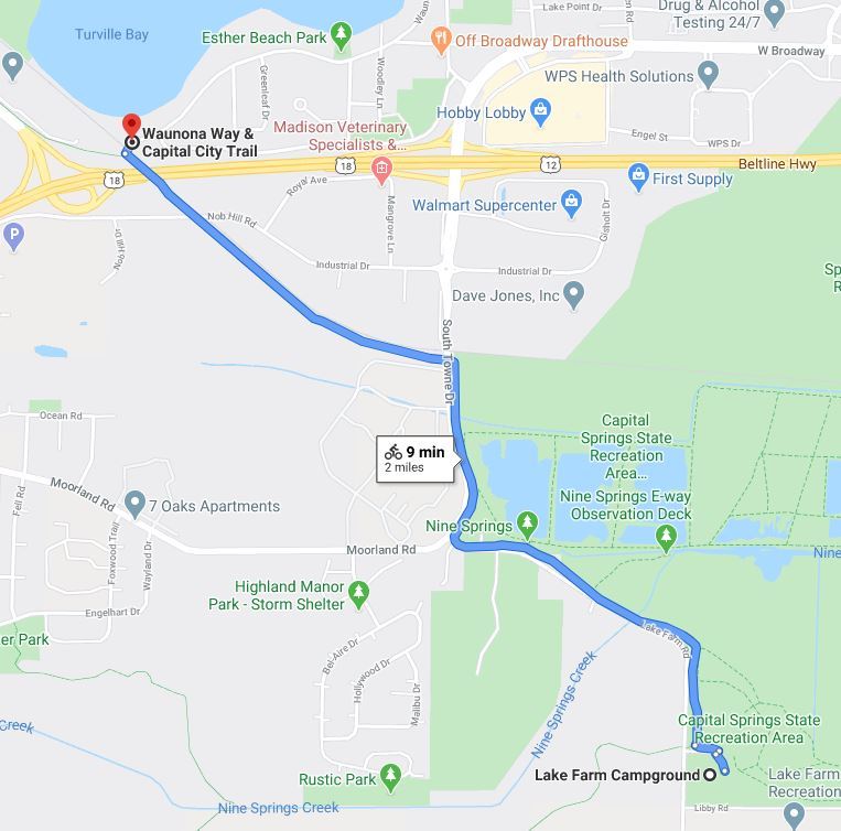
At Nob Hill Road there is a kiosk where you can purchase a state trail pass for the Capital City State trail. Check the website for details about obtaining a pass during Covid-19. After crossing South Towne drive, on the right is the Madison Metropolitan Sewerage District's (MMSD) wastewater treatment plant and on the left is MMSD's wildlife observation area and boardwalk. Arriving at Lake Farm campground, there is another junction. Turning right you will be continuing on the Capital City State trail. Turning left, you will be riding on the Lower Yahara River trail to McFarland.
______________________________________________________________________
Lower Yahara River Trail - 2.6 miles

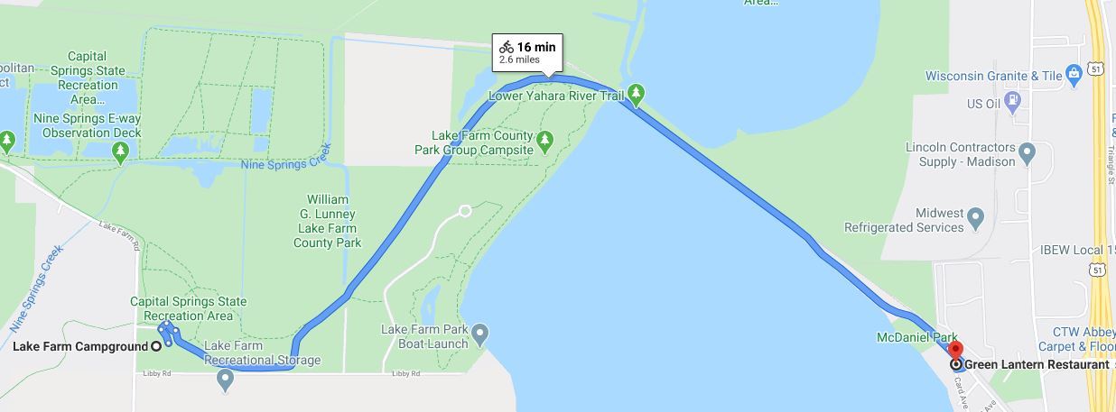
A trail pass is not required to bicycle the Lower Yahara River Trail. To your left is the Lussier Family Heritage Center which connects the community to natural resources through education, recreation, and experiences. The highlight of Lower Yahara River Trail is the mile-long boardwalk spanning Lake Waubesa. It is the longest inland boardwalk bridge constructed solely for non-motorized transportation in North America. At the eastern terminus of the bridge is McFarland's McDaniel Park and the Green Lantern Restaurant. At McDaniel Park there is a BCycle station.
________________________________________________________________________
Siggelkow Road - 1.0 miles


Turn left on Siggelkow's Road bike lane for one mile until you reach Marsh Road where you will turn left.
_________________________________________________________________________
Siggelkow Road to Pflaum Road - 2.7 miles

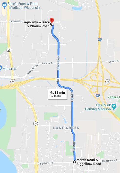
There is a bike lane on Marsh Road. An overpass takes you over Highway 18. At the stop sign after the overpass, you will arrive at the 4-way stop which is located at the intersection of Femrite Drive/Agriculture Drive. Continue straight ahead on Agriculture Drive.
There are two notable buildings on this stretch of Agriculture Drive. The first right after the Femrite Drive intersection is Fen Oak Drive where at 5201 Fen Oak Drive you can explore the Dane County Extension Teaching Garden with over 850 varieties of perennials, shrubs & trees that are midwest hardy. Further down on the right is World Dairy Drive that leads to the Wisconsin Department of Agriculture, Trade and Consumer Protection building.
But you want to stay on Agriculture drive where the road bends a little to the left until you reach Pflaum Road where you will turn right.
_________________________________________________________________________
Pflaum Road to Capital City Trail - 2.6 miles
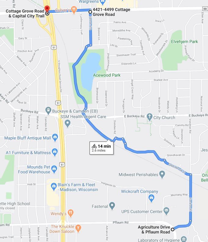
Travel 100 yards on Pflaum Road until you reach Vondron Road. After the railroad tracks on Vondron Road, take the first left onto Pebblebrook Drive. Take Pebblebrook Drive until you reach the first left - Sandlewood Circle. On the left of Sandlewood Circle you will see an unmarked bike/pedestrian path that runs for 500 yards to Leona Court. Take Leona Court for a half block to Tarragon Drive. Turn left on Tarragon Drive for 50 feet where you will see the start of the Capital City Bike path at 1933 Tarragon Drive.
Take the Capital City Bike path to E. Buckeye Road. Cross E. Buckeye where you will see the sign for the Acewood Interior Bike Path. Continue on the path for one block to Deerwood Drive. At that intersection you will see an unmarked path which is the Acewood Interior Bike Path. Continue on that path to Leo drive and take the first left onto Vernon Avenue. Vernon Avenue dead ends onto Cottage Grove Road.
On Cottage Grove Road you turn left. On Cottage Grove Road you can either take the sidewalk on the south side or the bike lane on the north side for a half mile until you reach the Capital City Trail located underneath the Highway51/S. Stoughton Road overpass.
_________________________________________________________________________
Capital City Trail to Monona Terrace - 4.7 miles
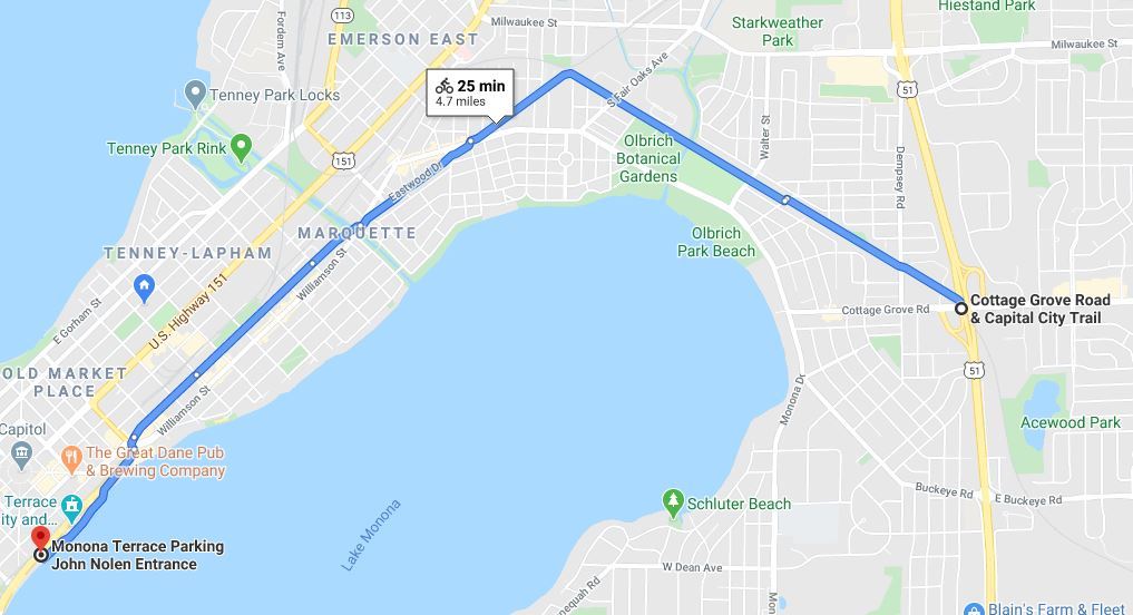
The final stretch follows the Capital City Trail back to Monona Terrace. About a mile along the route you will come across Olbrich Botanical Gardens. Across from Olbrich is the Garver Feed Mill where you can get pizza and ice cream. Further down along Atwood Avenue you can get ice cream at the Chocolate Shoppe Ice Cream Company (2322 Atwood Avenue) or the Sassy Scoop (2302 Atwood Avenue), both of which have outdoor seating along the trail. The trail to Monona Terrace then parallels Atwood Avenue and Williamson Street. Both streets have a cornucopia of establishments for food and drink.
_________________________________________________________________________
BCycle Station along the Route
Madison BCycle has a number of stations along the route where you can rent an electric bicycle. The following map lists some stations within a block of the route.

_________________________________________________________________________
Other Resources
Dane County Bicycle Map
Madison BCycle
Madison Bikes Community (Facebook)
Madison Bikes
Bicycle Benefits
Top 10 Trails to Try in Madison
Biking in Fitchburg
The Ultimate Guide to Biking in Madison Wisconsin
Your Guide to the Lake Monona Bike Loop
_______________________________________________________________________
Compiled by Bob Shaw - robert.e.shaw@gmail.com
June 2020; updated July 2026