
Bicycling around Lake Monona is very popular with the bicycle community. The route (12.6 miles) outlined below goes through a mixture of bicycle paths and lightly traveled streets and deviates slightly from the official Lake Loop but was selected because it is relatively flat and easy to follow. It takes about 75 minutes for the average cyclist.
_________________________________________________________________________
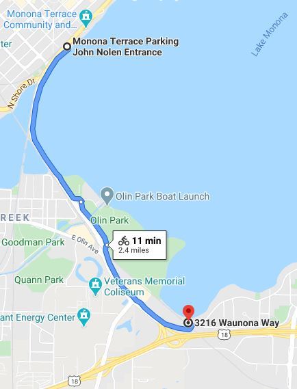
Monona Terrace to Waunona Way - 2.4 miles

This portion of the trail is flat and follows the John Nolen Drive Causeway. There are three junctions to other trails on this section. Shortly after leaving Monona Terrace there is a junction to the Brittingham Park Bike Path where after 500 yards, you can connect to the Southwest Commuter Path. At Olin Park, there is a junction to the Wingra Creek Bike Path which will take you to Fish Hatchery where you can connect to the Cannonball Trail. And just before Waunona Way and the railroad tracks, there is a junction that will enable you to continue on the Capital City Trail where you have the option of biking to Fitchburg or biking to McFarland via the Lower Yahara River Trail. But if you are continuing on the Lake Monona Trail, turn left onto Waunona Way.
_________________________________________________________________________
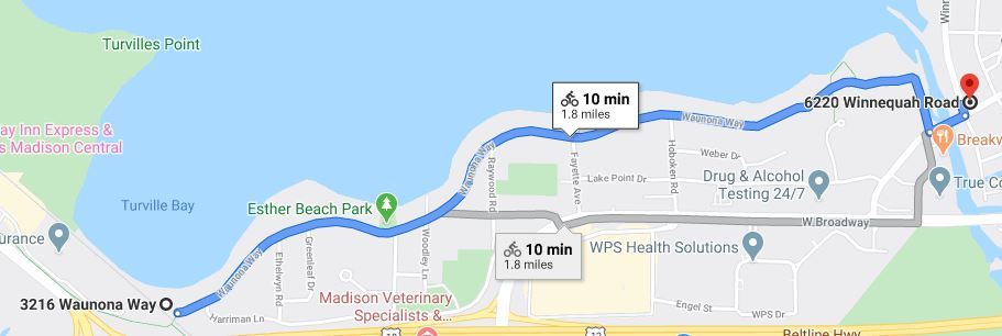
Waunona Way to Winnequah Road - 1.8 miles

 This section of the route goes along Waunona Road, a lightly traveled street. Esther Beach Park has nice views of the Capital and Lake Monona. At the end of Waunona Road, the path goes into A. O. Paunack Park. Follow the path in the park to Bridge road where you will turn left for one block to reach Winnequah Road.
______________________________________________________________________
Winnequah Road - 2.4 miles


At Winnequah road turn left and follow it for the next 2.4 miles. There is a bike lane for about half of the distance. At the stop sign at Maywood and Winnequah, turn left on Winnequah and go up the hill. When you go down the hill on Winnequah you will see a pond on your left side and a Lake Loop sign that says to turn left. Ignore that sign (the Lake Loop route has some steep hills on Tonywatha) and instead turn right on Winnequah Road. A few blocks further you will cross Nichols Road; the Monona Public Library is two blocks to the right at 1000 Nichols Road, a nice half-way point on the route. Continuing on Winnequah Road, at 4516 Winnequah (across from Schluter Park), you can get Babcock Hall ice cream at Monona Bait & Ice Cream Shop. At the intersection of Winnequah Road and West Coldspring Avenue (there is a sign that says Lake Loop), turn right onto W. Coldspring Avenue.
_________________________________________________________________________
Winnequah Road to Capital City Trail - 1.6 miles


Go three blocks on W. Coldspring Avenue to Monona drive. Cross Monona drive at the lights and go one block on E. Coldspring Avenue to Jerome street. Turn left on Jerome street and continue until you reach E. Buckeye road. At East Buckeye turn right for one block until you reach Davies street. At that intersection turn left on Davies where you will see an off-street bicycle path heading north. Continue on the bicycle path (Davies street turns into Dempsey street) for almost a mile (it crosses Cottage Grove Road where there is the Pinney Branch Library) until you reach the railroad tracks on Dempsey. Just after the railroad tracks, you will turn left onto the Capital City Trail.
_________________________________________________________________________
Capital City Trail at Dempsey to Monona Terrace - 4.5 miles


The final stretch follows the Capital City Trail back to Monona Terrace. About a mile along the route you will come across Olbrich Botanical Gardens. Across from Olbrich is the Garver Feed Mill where you can get pizza and ice cream. Further down along Atwood Avenue you can get ice cream at the Chocolate Shoppe Ice Cream Company (2322 Atwood Avenue) or the Sassy Scoop (2302 Atwood Avenue), both of which have outdoor seating along the trail. The trail then parallels Atwood Avenue and Williamson Street and both streets have a cornucopia of establishments for food and drink.
_________________________________________________________________________
BCycle Stations along the Route
Madison BCycle has a number of stations along the route where you can rent an electric bicycle. The following map lists some stations within a block of the route.

_________________________________________________________________________
Other Resources
Dane County Bicycle Map
Madison BCycle
Madison Bikes Community (Facebook)
Madison Bikes
Bicycle Benefits
Top 10 Trails to Try in Madison
Biking in Fitchburg
The Ultimate Guide to Biking in Madison Wisconsin
Your Guide to the Lake Monona Bike Loop
_______________________________________________________________________
Compiled by Bob Shaw - robert.e.shaw@gmail.com
June 2020; updated June 2025
